The Whale Route (Route des Baleines) stretches for over 800 km (497 mi.) along the St. Lawrence River, from Tadoussac to Kegaska, at the end of Route 138. You can also explore toward the north, heading out from Baie-Comeau, to see the gigantic hydroelectric facilities―our very own modern-day pyramids!
How to get there
Distance between main cities
Did you know?
To be discovered absolutely
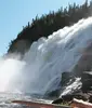
We do everything in a big way, so be ready to open your eyes wide. Whales, rocks shaped like flower pots and the Jardin des glaciers: it’s all enormous.
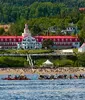
Tadoussac
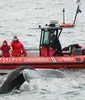
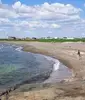
Sitting along the majestic St. Lawrence River, Tadoussac is the starting point of the Whale Route (Route des Baleines), at the mouth of the Fjord du Saguenay. It’s where the sea giants come to feed in summer and fall.
In addition to whale-watching cruises, Tadoussac is also known for its history, lively summer seasons and Festival de la Chanson.
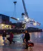
Tadoussac was New France’s first fur trading post in 1600. Today, the beavers and other animals live quietly in nature. Visitors can discover the way of life of long ago at the Chauvin Trading Post.
Tadoussac bay is part of the Most Beautiful Bays in the World club.


Whale Route (Route des Baleines)
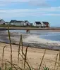
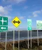
It’s not the squirrels in our backyard that grab our attention; it’s the whales in our river. In fact, from Tadoussac onward, Route 138 takes on a new name, becoming the Whale Route (Route des Baleines), marked with attractive blue signs with a little white whale, to make sure you don’t miss the many sites devoted to our marine mammals.
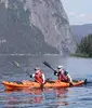
The route runs for 880 km (547 mi.), following the path of these sea giants. Thirteen whale species roam the St. Lawrence River during the summer and fall. You can catch sight of them from the shore or on the water, aboard a cruise boat, sea kayak or Zodiac boat, and you will even hear them sing!
A blue whale’s tongue weighs as much as a female elephant, or around 3,629 kg (8,000 lb.).


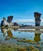
Mingan Archipelago
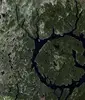
Protecting more than 1,000 islands and islets over 110 km2 (43 sq. mi.), the Mingan Archipelago National Park Reserve has the largest concentration of monoliths in Canada. Mono what? Monoliths are colossal upright limestone outcroppings. An unusual Côte-Nord geological feature, these rocks erode over time as they are sculpted by the sea and wind. They take the shape of flower pots and other surprising artistic forms created by Mother Nature.
Whether from a boat, kayak, sailboat or stand-up paddleboard, or on foot on the islands, you’ll be able to immortalize this corner of the world by photographing the unbridled landscapes, unique flora—including rare plants—and bustling wildlife. By the way, if you’re looking for sea parrots on the Île aux Perroquets island, you should know that “perroquet” is the nickname given to the comical Atlantic puffin.
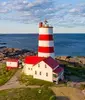
You can spend the night at an inn set in the former Île aux Perroquets lighthouse.